Snapshot · 21 October 2026
3 Ruth Miller Close
Low density residential lot of 827 m² with a 18.2 m frontage to Ruth Miller Close, facing south. The land rises 3.6 m from the front boundary to the rear (10%, 1 in 10). Council maps a low flood likelihood here. Overlays: Dwelling house character, Significant landscape tree, Brisbane River flood planning area, Biodiversity area.
Where it sits
Fig Tree Pocket, Brisbane City Council area
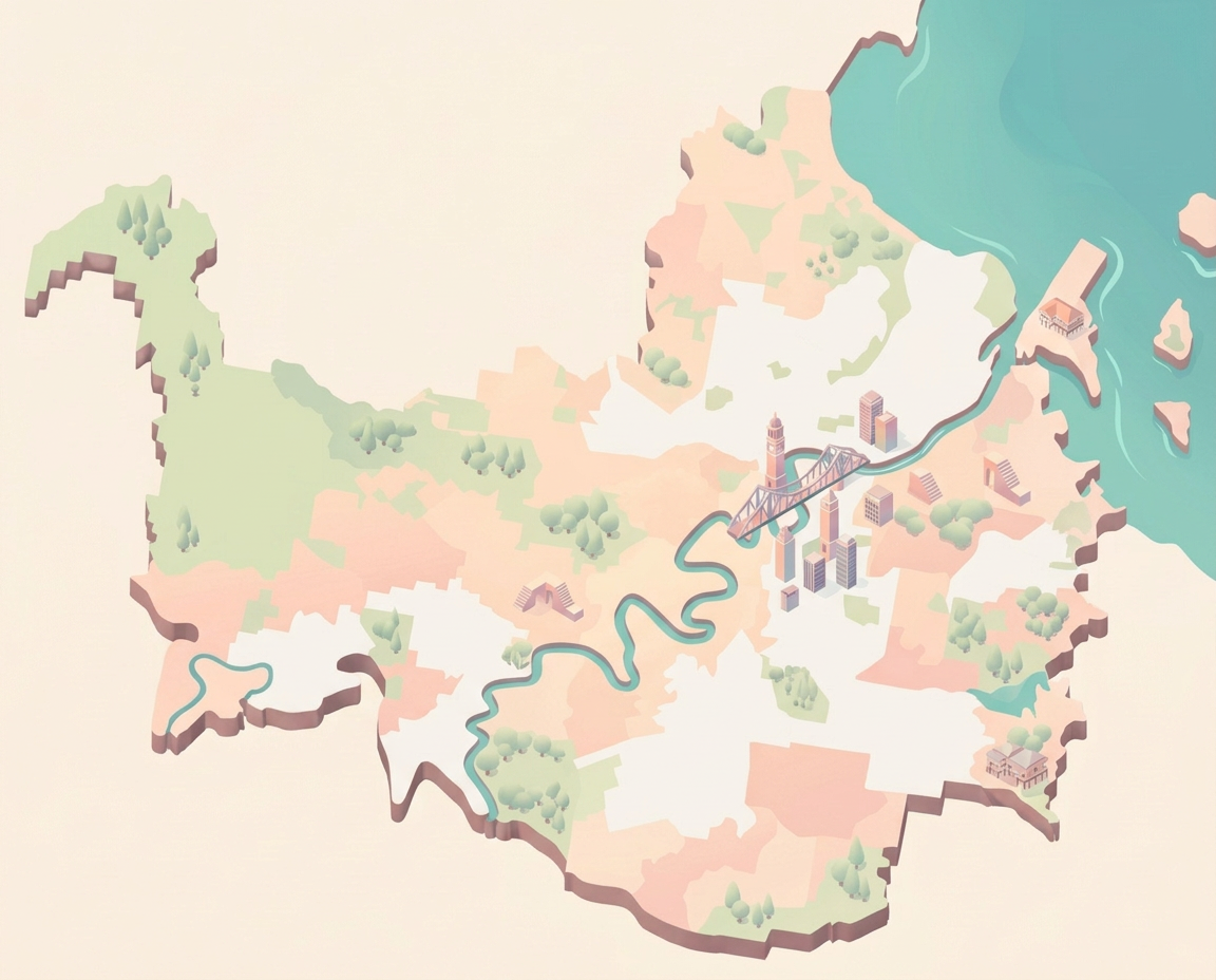
- Address3 Ruth Miller Close, Fig Tree Pocket
- Lot boundaryLot 3 on SP291008
- Zoning and overlaysLDR: Low density residential
- Council flood data
- Slope and levels
- Aerial photo
Unit
This unit and its building
The unit's own lot, the community titles scheme it belongs to and where it sits in the building, from Council and State records.
The site
Lot and terrain
Lot lines from Council’s property boundaries. Ground levels from the State’s 1 m LiDAR elevation model.
Site plan
Terrain block
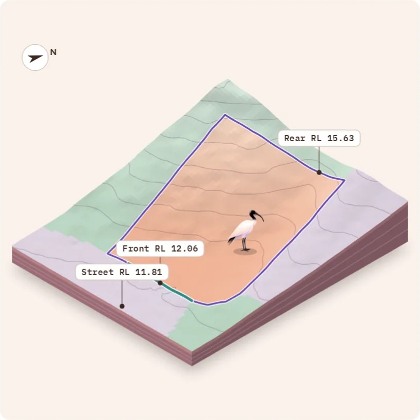
Slope
From the street to the back fence
Ground levels along the line A to A′ on the site plan, through the middle of the lot. Move along the chart to read any point.
Show the levels as a table
| From front (m) | Ground (RL) | Against front (m) | Where |
|---|---|---|---|
| −8 | 11.79 | −0.26 | Street |
| −6 | 11.86 | −0.20 | Street |
| −4 | 11.95 | −0.11 | Street |
| −2 | 12.00 | −0.06 | Street |
| 0 | 12.06 | 0.00 | Front boundary |
| 2 | 12.13 | 0.07 | Lot |
| 4 | 12.22 | 0.16 | Lot |
| 6 | 12.27 | 0.21 | Lot |
| 8 | 12.32 | 0.26 | Lot |
| 10 | 12.42 | 0.36 | Lot |
| 12 | 12.74 | 0.69 | Lot |
| 14 | 12.98 | 0.93 | Lot |
| 16 | 13.11 | 1.06 | Lot |
| 18 | 13.49 | 1.43 | Lot |
| 20 | 13.77 | 1.72 | Lot |
| 22 | 14.01 | 1.96 | Lot |
| 24 | 14.24 | 2.19 | Lot |
| 26 | 14.48 | 2.43 | Lot |
| 28 | 14.62 | 2.57 | Lot |
| 30 | 14.89 | 2.83 | Lot |
| 32 | 15.06 | 3.01 | Lot |
| 34 | 15.40 | 3.34 | Lot |
| 36 | 15.89 | 3.83 | Past the rear |
| 38 | 16.37 | 4.32 | Past the rear |
What the slope means
- The land rises 3.6 m from the front boundary to the rear, 10% or 1 in 10 on average.
- The front boundary is about level with the road, so access is easy.
- Rain runs towards the street, which keeps stormwater simple. Higher land behind can send runoff across the lot in storms.
- Expect a split-level or suspended floor, or cut and fill with retaining walls.
- The ground also falls 2.3 m across the frontage, lower on the right as seen from the street.
- The steepest 5 m stretch, 16 to 21 m in from the front, is 16%.
- The rear faces north, the best orientation for sun on the back yard and living areas in Brisbane.
Key levels
Planning
Zoning and overlays
Brisbane City Plan 2014 mapping that touches this lot. A plain-English guide, not the planning scheme itself.
Zone
Low density residential
Mostly detached houses up to 2 storeys (9.5 m). A secondary dwelling is often possible. Dual occupancy and subdivision depend on lot size, frontage and location, so check the zone code before counting on them.
Neighbourhood plan
Fig Tree Pocket. A neighbourhood plan can change heights, setbacks and lot sizes for its area, so read it with the zone.
Overlays on this lot
4 foundBrisbane River flood planning areaBrisbane River flood planning area 5: QPP flood planning area 5
Inside a mapped river flood planning area. Minimum floor levels and flood-resilient design apply.
Significant landscape treeLandscape features site sub-category
Protected trees are mapped here. Removing or damaging them generally needs a permit.
Biodiversity areaBiodiversity area (High ecological significance): 2016 Major Amendment B
Ecologically important vegetation or habitat. Clearing and the development footprint are restricted.
Dwelling house character
Council maps this street for its established housing character. A new house or extension may need to meet the overlay code on height, setbacks and garages, so check it before design starts.
Development
Council applications
Development applications on this lot, the land it was created from and the streets around it, from the council's Development.i register, with a summary on request.
summary
The register shows two subdivision applications linked to this lot, one approved in December 2021 and one withdrawn in 2023, and nearby activity is light, with two applications still open.
Checked 19 October 2026 at 9:20 pm. No decision documents read. Medium confidence.
The register shows two applications linked to this lot since 1 January 2004. A005878128 was a code assessable Reconfigure a Lot (subdivision) application on the earlier lot 3SP291008. It was lodged in November 2021 and approved in December 2021. A006145375 was also a code assessable subdivision application. It was lodged in November 2022 and recorded as withdrawn, with a decision date of October 2023. Both records carry Sprenger St addresses, not Ruth Miller Close. No decision documents were attached, so the conditions and reasons for either application are not known. No historic records over the current parcel were found.
Within 500 metres over the last 24 months there are 4 applications. Three are house and building work and one is a subdivision. Two are still in progress. A007118017 is a dwelling house application (building work and material change of use) at 304 metres, lodged in September 2026 and being assessed. A006756677 is an impact assessable subdivision with an access easement at 416 metres, lodged in April 2025 and shown as on public notification.
- No decision documents were provided, so no conditions or reasons have been read. Only register summaries are used.
- The online register covers applications lodged since 1 January 2004. Older records, and anything not listed against this parcel, would not appear.
- This is general information only, not planning or legal advice.
Decision documents are linked for your review. The summary uses council records only to protect personal information.
A summary of council records, not planning or legal advice. Check the applications and their documents in Development.i before relying on it. People's names are left out on purpose.
Applications on this lot
Newest first, including the land parcels this lot was created from.
| Lodged | Application | What | Status | Decided | Files |
|---|---|---|---|---|---|
| 10 Nov 2022 | A006145375 | Subdivision Subdivision of Land | 16 Oct 2023 | Documents | |
| 10 Nov 2021 | A005878128 Earlier lot 3SP291008 | Subdivision Subdivision of Land | 22 Dec 2021 | Documents |
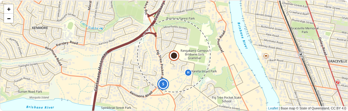
Applications nearby
Lodged within 500 m in the last 2 years, newest first. Showing those in progress, subdivisions, new uses and new titles; 2 house renovations and similar are hidden.
| Lodged | Address | What | Status | Away | Files |
|---|---|---|---|---|---|
| 25 Sept 2026 | 30 Karella St Fig Tree Pocket QLD 4069 A007118017 | House and building work Dwelling house | 300 m | Documents | |
| 23 Apr 2025 | 430 Fig Tree Pocket Rd Fig Tree Pocket QLD 4069 A006756677 | Subdivision Access Easement, Subdivision of Land | 420 m | Documents |
Source: Brisbane City Council, Development.i, CC BY 4.0. Checked 19 October 2026 at 9:20 pm with 6 requests. Priority Development Areas are not in Development.i.
Flood
Council flood information
Brisbane City Council Flood Awareness data for this lot, the same figures behind a FloodWise Property Report.
Council rates the flood likelihood as low: flooding is unlikely but may occur in a rare flood.
Recorded floods reached RL 10.10 here in January 2011.
For a formal check, order a FloodWise Property Report from Council’s Flood Awareness Map.
Levels for this lot
RL is metres above sea level (AHD). AEP is the chance of that flood in any year. Letters after a floor level are Council’s data quality rating.
Market
Market and price estimate
A price guide for this address from an estimate of recent sales, with links to look further.
Price estimate
Estimate from recent comparable sales, low confidence. LoQal's middle estimate $2.5m.
Recent sales nearby
Similar homes sold recently, closest first. Bed / bath / car.
| Address | Bed / bath / car | Land (m²) | Price | Sold | Away |
|---|---|---|---|---|---|
| 17 Barrygroves Court, Fig Tree Pocket | 5 / 3 / 2 | 804 | $2,625,000 | Jan 2026 | 1.4 km |
| 59 Ruth Miller Close, Fig Tree Pocket | 5 / 3 / 2 | 2,370 | $2,950,000 | Mar 2026 | 0.2 km |
| 20 Serene Place, Fig Tree Pocket | 5 / 2 / 3 | 1,000 | $2,850,000 | Feb 2026 | 1.5 km |
| 43 Cubberla Street, Fig Tree Pocket | 4 / 4 / 2 | 1,101 | $2,650,000 | Mar 2026 | 1.0 km |
| 2 Norman Street, Fig Tree Pocket | 4 / 3 / 2 | 877 | $1,564,000 | Mar 2026 | 0.8 km |
| 55 Mandalay Street, Fig Tree Pocket | 4 / 2 / 2 | 685 | $2,010,000 | Apr 2026 | 2.3 km |
| 28 Ruth Miller Close, Fig Tree Pocket | 5 / 3 / 2 | 1,002 | $2,531,000 | June 2023 | 0.1 km |
An automated guide from LoQal’s sales data, not a valuation. Condition, renovations, views and the final negotiation can put the sale price well outside this range. Checked 21 October 2026 at 2:03 pm.
The saved appraisal conflicts with the likely-sale range. The price estimate is shown instead; request a new appraisal to review the evidence. The only recent same-street sale is 59 Ruth Miller Close in March 2026 on 2,370 m², nearly three times the subject's land, so it caps the evidence rather than anchoring it. The 2023 sale of 28 Ruth Miller Close on 1,002 m² is outside 18 months and is shown for reference only. The nearest land-size matches are 17 Barrygroves Court (804 m², 5 bed, 3 bath, 2 car) and 2 Norman Street (877 m², 4 bed, 3 bath, 2 car). Their time-adjusted prices differ by about $1.0 million, and the gap cannot be explained without floor area and condition data. Larger-lot sales at 20 Serene Place (1,000 m²) and 43 Cubberla Street (1,101 m²) adjust to the mid to high $2.5 million range, and the subject has less land than both. The 55 Mandalay Street sale on 685 m² adjusts to the low $1.9 million range and marks the lower end for a smaller lot in the suburb. Hugo Design records show 5 bedrooms, 3 bathrooms and 2 car spaces on 827 m², which is consistent with the stronger comparables, but the position, aspect, level, condition and floor area of the house are unconfirmed. The corner lot, moderate slope, character and biodiversity overlays, and significant. Suburb medians are up strongly over 12 months, but the Brisbane market has fallen from its May 2026 peak, auction clearance is near record lows, and a cash rate rise on 29 September 2026 is reducing buyer borrowing capacity.
Market pulse
Brisbane market: Cold
Prices falling, buyers in charge. High confidence.
Cold: values fell 1.5% in September 2026 (Cotality), the clearance rate is 21.2% and homes take 35 days to sell, against 19 a year ago.
Fig Tree Pocket
Warmer than Brisbane
House values outpaced Brisbane over 12 months (+13.9% against +5.9%) and homes sell slower than across Brisbane (52 days against 35).
Checked 21 October 2026. Suburb figures are thinner than Brisbane's, so treat this as a rough guide.
Fig Tree Pocket's figures
| Figure | Latest | Reads as | Weight | Source |
|---|---|---|---|---|
| Median change over 12 months 12 months to July 2026 | +13.9% houses, against +5.9% for Brisbane | strongly warming | 40 | yourpropertyhound.com.au |
| Days on market July 2026 | 52 days, against 35 for Brisbane | strongly cooling | 20 | yourpropertyhound.com.au |
The trend line fills in week by week.
The figures behind it (8)
| Figure | Latest | Reads as | Weight | Source |
|---|---|---|---|---|
| Home values, last month September 2026 | -1.5% Cotality, -0.2% PropTrack | strongly cooling | 30 | Cotality and PropTrack |
| Auction clearance rate week ending 4 October 2026 (final) | 21.2% (138 auctions) | strongly cooling | 10 | cotality.com |
| Days on market three months to August 2026 (median, Cotality) | 35 days, against 19 a year earlier | strongly cooling | 10 | realestatebusiness.com.au |
| Listings against a year earlier four weeks ending 6 September 2026 (Cotality) | up 53.3% (total listings) | strongly cooling | 10 | realestatebusiness.com.au |
| Sales against a year earlier latest three months, Cotality estimate reported September 20 | down 27.2% | strongly cooling | 5 | smartpropertyinvestment.com.au |
| Interest rates 30 Sept 2026 | cash rate 4.60%, up 0.25% in September | cooling | 10 | rba.gov.au |
| Consumer sentiment October 2026 | 80.4 (100 is neutral), time to buy a dwelling 88.4 | strongly cooling | 5 | library.westpaciq.com.au |
| Tone of the news last month | negative | strongly cooling | 10 | cotality.com |
In the news
- Final Clearance Rates, week ending 4 October 2026: Brisbane clearance rate lowest since November 2008 4 Oct 2026
- Auction clearance rate sinks to three-month low, Sydney and Melbourne property a 'drag' on results 5 Oct 2026
- Behind the headlines: The true scope of Brisbane's slowdown 1 Oct 2026
How it works: a research agent finds the latest published figures each week; fixed rules turn each into a lean from strongly cooling to strongly warming, and the weighted average sets the reading (50 is steady). Missing figures are left out.
An indicative reading of the Brisbane housing market from published figures, not financial advice.
Look further
Buying costs
Stamp duty and repayments
Queensland transfer duty and loan repayments. They start from the price estimate's middle figure; change any number to suit.
Starting figure: LoQal's middle estimate ($2.5m)
Stamp duty
Home concession rate, for a home you move into within a year.
Rates for contracts signed now. A home concession is reassessed if you don't move in within a year. Developers buying several lots pay duty on the total price.
Loan repayments
Principal and interest over 30 years at 6.42%. Big four average for this kind of loan, 9 October 2026.
Where the default rate comes from
Each big four bank's lowest advertised variable rate for new loans at 70 to 80% LVR, as published on 9 October 2026, after the 0.25% rise that took effect that day. The default is their average. Above 80% LVR it uses their average for 80 to 90% LVR (owner-occupier 7.08%, investment 7.42%). Owner-occupier interest only uses the banks that offer it (6.96%).
| Bank | Loan | Owner-occupier, principal and interest |
|---|---|---|
| CommBank | Digi Home Loan | 6.39% |
| Westpac | Flexi First Option, online offer | 6.34% |
| NAB | Tailored Home Loan, from | 6.44% |
| ANZ | ANZ Plus (home), Simplicity PLUS (investment) | 6.50% |
Rates change often: confirm with the lender.
Cash needed to settle
Estimates only, not financial or legal advice. The Queensland Revenue Office assesses the duty; concessions have conditions such as moving in within a year, and from 1 August 2026 Australian citizenship or permanent residency. Not included: lenders mortgage insurance, legal and conveyancing costs, inspections, bank fees and any first home owner grant. Check the duty with the Queensland Revenue Office calculator.
Schools
School catchments
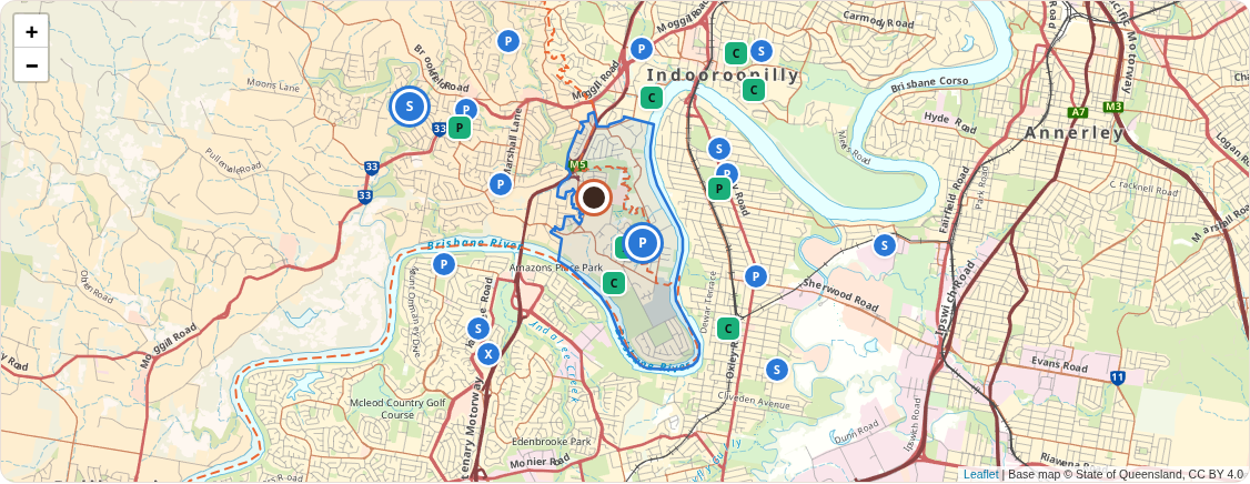
The state school catchments this address sits in, and state and non-government schools nearby.
| School | Level | Sector | Years | Distance | Results |
|---|---|---|---|---|---|
| Fig Tree Pocket State School In catchment | Primary | State | Prep to Year 6 | 1.0 km | My School |
| Kenmore State High School In catchment | Secondary | State | Years 7 to 12 | 3.1 km | My School |
| Mancel College | Special school | Non-government | Prep to Year 12 | 910 m | My School |
| Brisbane Montessori School | Primary and secondary | Non-government | Prep to Year 12 | 1.3 km | My School |
| Kenmore South State School | Primary | State | Prep to Year 6 | 1.4 km | My School |
| Ambrose Treacy College | Primary and secondary | Catholic | Years 4 to 12 | 1.7 km | My School |
| Christ the King School | Primary | Catholic | Prep to Year 6 | 1.9 km | My School |
| Milpera State High School | Secondary | State | Years 7 to 12 | 2.0 km | My School |
| Graceville State School | Primary | State | Prep to Year 6 | 2.1 km | My School |
| Our Lady of the Rosary School | Primary | Catholic | Prep to Year 6 | 2.3 km | My School |
| Kenmore State School | Primary | State | Prep to Year 6 | 2.4 km | My School |
| Indooroopilly State School | Primary | State | Prep to Year 6 | 2.4 km | My School |
| Jindalee State School | Primary | State | Prep to Year 6 | 2.5 km | My School |
| Centenary State High School | Secondary | State | Years 7 to 12 | 2.7 km | My School |
| Chapel Hill State School | Primary | State | Prep to Year 6 | 2.7 km | My School |
| Sherwood State School | Primary | State | Prep to Year 6 | 2.7 km | My School |
| St Aidan's Anglican Girls School | Primary and secondary | Non-government | Prep to Year 12 | 2.9 km | My School |
| Mount Ommaney Special School | Special school | State | Varies | 2.9 km | My School |
| St Peters Lutheran College | Primary and secondary | Non-government | Prep to Year 12 | 2.9 km | My School |
| Brigidine College | Primary and secondary | Catholic | Years 5 to 12 | 3.1 km | My School |
| Indooroopilly State High School | Secondary | State | Years 7 to 12 | 3.4 km | My School |
| Corinda State High School | Secondary | State | Years 7 to 12 | 3.8 km | My School |
| Queensland Academy for Science Mathematics and Technology | Secondary | State | Years 7 to 12 | 4.4 km | My School |
| Millenba | Secondary | State | Years 7 to 12 | 4.5 km | My School |
| Brisbane Boys' College | Primary and secondary | Non-government | Prep to Year 12 | 4.7 km | My School |
| Omni Academies of Learning | Secondary | Non-government | Years 7 to 12 | 5.2 km | My School |
Catchments for 2026 and school locations: Queensland Department of Education, CC BY 4.0. Only state schools have catchments: living in one generally guarantees a place there. Non-government schools set their own enrolment rules. Catchments change each year, so confirm with the school. My School (ACARA) shows each school's NAPLAN results; you accept its terms on the first visit. Straight-line distances.
Neighbourhood
Shops, transport and amenities
Public transport, shopping, health, childcare, parks and local agents around the address.
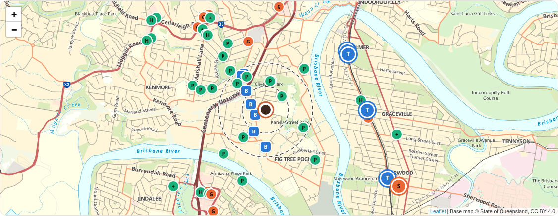
Shops and amenities: Geoapify, map data © OpenStreetMap contributors. Stops: Translink, CC BY 4.0. Walking times are estimates from straight-line distance.
Public transport
Train
- Chelmer station1.7 km, 28 min walkZone 1 · Timetable
- Graceville station1.7 km, 28 min walkZone 1/2 · Timetable
- Sherwood station2.4 km, 39 min walkZone 2 · Timetable
Busway and Metro
- Honour Ave at Chelmer station1.7 km, 28 min walkZone 2 · Timetable
Bus stops within 800 m
- Fig Tree Pocket Rd near Sprenger St190 m, 3 min walkZone 2 · Timetable
- Fig Tree Pocket Rd near Aylesbury St270 m, 4 min walkZone 2 · Timetable
- Fig Tree Pocket Rd near Kenmore Rd420 m, 7 min walkZone 2 · Timetable
- Fig Tree Pocket on Centenary Highway siding460 m, 7 min walkZone 2 · Timetable
- Fig Tree Pocket Rd at Thiesfield Street630 m, 10 min walkZone 2 · Timetable
- Fig Tree Pocket Rd at Kenmore Rugby Club:710 m, 12 min walkZone 2 · Timetable
- Fig Tree Pocket Rd near Kenmore Rugby Club720 m, 12 min walkZone 2 · Timetable
Stops from Translink. Timetables open on Translink's site.
Shopping centres
- Sherwood Central Shopping centre2.6 km
- Indooroopilly Shopping Centre Shopping centre2.7 km
- Indooroopilly Junction Shopping centre2.8 km
- Mt Ommaney Centre Shopping centre3.7 km
- Oxley Central Shopping centre4.0 km
- The Oxley Station Shopping centre4.0 km
Supermarkets and daily needs
- Coles Supermarket1.7 km, 28 min walk
- Graceville Foodmarket Supermarket1.7 km, 28 min walk
- Aldi Supermarket1.9 km, 31 min walk
- Woolworths Supermarket1.9 km, 31 min walk
- Captain Convenience Convenience store1.2 km, 20 min walk
- Jindalee Bakery Bakery1.7 km, 28 min walk
Cafes and dining
None within 1.2 km.
Health
- Chemist Warehouse Pharmacy1.7 km, 28 min walk
- Discount Drug Stores Pharmacy1.7 km, 28 min walk
- Kenmore Denture Clinic Dentist1.6 km, 26 min walk
- Canossa Private Hospital Hospital3.8 km
- Westside Private Hospital Hospital3.9 km
Childcare and libraries
None within 2.5 km.
Parks and sport
- Cliveden Park Park380 m, 6 min walk
- Rainbow Forest Park Park510 m, 8 min walk
- Fig Tree Common Park Park600 m, 10 min walk
- Unnamed playground Playground500 m, 8 min walk
Sources
Where this comes from
- Brisbane City Council open data: property boundaries, addresses, City Plan 2014 zoning, overlays and neighbourhood plans, and Flood Awareness data. CC BY 4.0.
- Queensland Government spatial data: address search, the 1 m LiDAR elevation model and the latest State aerial imagery. CC BY 4.0.
- Price estimate: property details and sales history, recent sales for the price guide, checked 21 October 2026 at 2:03 pm.
- Queensland Government spatial data: school catchments and school locations from the Queensland Department of Education, and public transport stops from Translink, and the base maps. CC BY 4.0. Shops and amenities: Geoapify, with data © OpenStreetMap contributors. Stamp duty: Queensland Revenue Office rates. Interest rates: big four banks' published rates, 9 October 2026. Council applications: Brisbane City Council's Development.i, CC BY 4.0, summarised by a research agent. Market pulse: published figures found by a research agent and scored by fixed rules; each figure links to its source in the Market section. Land values: Queensland Valuer-General, © State of Queensland, CC BY 4.0. Agent-style appraisal: sales found by a research agent, each checked against Council records and adjusted by fixed rules.
Fetched live on 21 October 2026 at 2:01 pm in 5.4 seconds.
Council data is not intended for conveyancing. For due diligence, use a Council planning and development certificate, a FloodWise Property Report, a title search and a survey.